Earthquake Liquefaction Safety
Installed 31 Oct 2005. Latest Update 27 Nov 2017.New or modified material is in bold.
Special Note
According to the http://www.ceri.memphis.edu/~ellis/NMSZ/nmsz.html [Link no longer works.] Center for Earthquake Research and Information (CERI) at Memphis, TN, more than 10,000 square kilometers of ground liquefied as a result of the New Madrid seismic zone earthquakes that occurred during the winter of 1811-1812. (It is not clear, at this writing, whether this means surface liquefaction or a combination of surface and sub-surface.) An area approximately equal to 10,000 square miles is represented by the diagonally oriented rectangle on the map below.
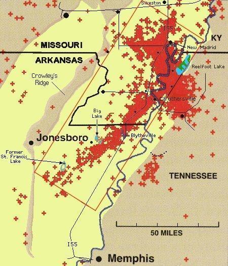
New Madrid Seismic Zone (USA)
Original image, courtesy http://quake.wr.usgs.gov/prepare/factsheets/NewMadrid/ [Link no longer works.] U.S. Geological Survey,
shows locations of earthquakes from 1974-1998. Flood plains (yellow areas on this map) are most subject to liquefaction.
The former St. Francis Lake is reported to have been created at the time of the New Madrid earthquakes of 1811-1812. (The author of these pages harbors a suspicion that a meteorite impact may have been the primary cause of the lake's creation and triggering event for the earthquakes. From this line of reasoning it would follow that Big Lake and Reelfoot Lake may ultimately also have a meteorite impact origin.)
The town of Caruthersville, Missouri (Little Pararie in 1811) is situated on the west bank of the Mississippi river and is more or less on top of the main part of the New Madrid fault. This would seem to make it the most likely population center in the New Madrid fault zone to suffer a surface liquefaction event.
The geological feature known as Crowley's Ridge (left side of map) may have been a barrier island in the ancient Gulf of Mexico. If you have a high speed internet connection, please see the 1889 Map of Crowley's Ridge and of the Flood Plains of Adjacent Streams. This second map is quite large (2.2 Megs), and you'll need to scroll around to see everything. On it, the flood plains are shaded in brown. Note the chalk bluff where Crowley's Ridge intersects the Missouri/Arkansas border. (The 1889 Map was copied, in photo-mosaic form, from the University of Alabama Historical Map Archive. [Third page, 24th image.]
If a prolonged magnitude 6.0 or greater earthquake should occur in a river flood plain region, along the New Madrid fault for example, there could be temporary widespread liquefaction (soil turning to quicksand). Currently, the author of this page is uninformed as to how long a time the word temporary might imply; hours? days?
Some experts say that highways could sink below the surface. New roads, or roads with un-compacted roadbeds, should be most susceptible to liquefaction. Motor vehicles in liquefaction zones might suffer fates worse than muddy tires.
The amount of liquefaction that might occur should be related to the amount of sub-surface ground water, its proximity to the surface, the soil type, and the magnitude and duration of the seismic activity at a given location.
The closer one is to any given river or other body of water the closer the ground water will be to the surface, hence there will be a greater chance of liquefaction. During times of river high water the sub-surface water level will probably also be higher, so liquefaction could occur further from the river than in general.
Ricelands on sandy soil may be particularly susceptible to liquefaction, especially when the rice fields are covered with water. Water is typically pumped to the surface from depths down to 90 feet or more. (Liquefaction at that depth would probably not produce quicksand at the surface but may produce widely scattered-sand blow ruptures and/or geysers.) Surface water that seeps into the soil beneath the rice fields could be problematic in the event of a strong prologed earthquake. Rice farmers might consider providing liquefaction buffer zones between their rice fields and nearby heavily traveled roads.
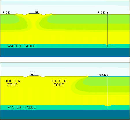
Rice Fields Without and With Liquefaction Buffer Zones
Catfish farms pose a potentially different kind of problem. Since their bottoms are normally sealed against water seepage, they might not be prone to contributing to liquefaction. On the other hand, when earthquake produced ground-waves roll across/through the ponds, their contents could slosh out like miniature tsunamis. These events could send vehicles tumbling to who knows where.
It might behoove inhabitants (and forewarned motorists) in probable liquefaction zones to store lifevests (or other floatation devices) and inflatable rafts or dingys in their vehicles. A raft or two around home or business might be in order as well. Vehicular rafts should be stocked with emergency food and water (especially water), some kind of flare or visual signalling device, and a first aid kit. These items should be tethered to the raft.
For general earthquake safety guidelines see: Earthquake Survival - What to do before, during and after an earthquake and preparing an earthquake survival kit for your home, automobile and office. Published by the Center for Earthquake Research and Information, University of Memphis, Memphis, TN.
The proprietor of this website is not liable for any
injuries or material losses suffered by persons who choose
to practice or employ the following suggested procedures.
You can, on the other hand, fashion very inexpensive (no frills) life rafts out of car or truck tire inner tubes and inflate them as needed with roadside tire inflation cannisters. Be sure that if you have a big size inner tube that you get an appropriately sized filler cannister.
Whichever kind of life raft you use, you should not try to inflate it inside your vehicle.
The filling cannisters I have seen have a threaded connection that attaches to the inner tube filler stem. It might be prudent to make the connection before a possible need for it's service ever arises.
Lower a window and hold the inflating life raft outside your vehicle.
When inflation is complete, climb out the window and get aboard, buttocks in the center of the inner tube.
It wouldn't hurt to practice this maneuver, before the biggie.
State and Federal emergency services might consider stockpiling inflatable life rafts for helicopter delivery to liquefaction-stranded motorists who don't have floation provisions.
Emergency service facilities and rescue helicopter pads, including their fueling systems, located in zones subject to liquefacation, should be earthquake proofed.
Links and Related Articles
Earthquakes and the New Madrid Fault LineOrigins of the New Madrid Fault - Mafic intrusions of plutons
Liquefaction Demonstration Activity
Key Words
Big Lake AR, Blytheville AR, Caruthersville MO, Hayti MO, I55, Liquefaction,Liquifaction, Manila AR, Marston MO, Misssissippi River, New Madrid MO, Osceola AR,
Portageville MO, Reelfoot Lake TN, Steele MO, Sunken Lands, Tiptonville TN