The Fires of Canneto di Caronia, Part 4
Prev |
1 |
2 |
3 |
4 |
5 |
Next
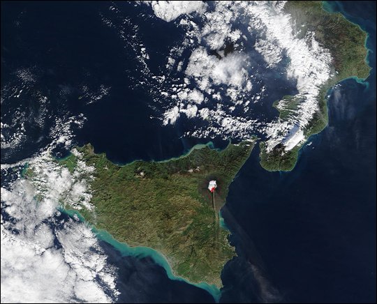
Etna seen by MODIS on 30 Dec 2002
9 March 2004
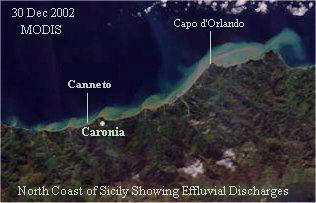
The following NASA MODIS image (From Dec 31, 2002 posting on the Natural
Hazards page, at the end of Part 3.) shows an unusual
amount of effluvial material spewing out of streams along the north coast
of Sicily on 30 December 2002. (Normally Sicily's coastal waters are
largely devoid of such material.) The south coast of Sicily showed similar
discharges. Actually the light-green to tan discoloration extends
much further to sea along the southern coast and the "spewing out" by
coastal streams does not seem nearly as pronounced as on the northern coast.
On the south coast it looks more like beach sand got agitated by wave
action and diffused to sea. The quantitative and qualitative differences
need explaining. [Added 10 March 2004.]
Is this unusual effluvial activity a side effect of earthquake agitation? Were there increases in water flow or just a increases in particulate content, or both? On-scene reports/observations are welcome.
10 March 2004
One might attempt to make a connection between the Stromboli landslides and resulting tsunami(s)
which occurred on 30 Dec (2002) and the discolored water along the coasts of Sicily, but
the landslides took place at 1:15 PM and 13:22 PM local time, whereas the MODIS image was made, at
around 10:00 to 10:30 AM (local), according to the position of the Etna plume shadow on the image.
13 March 2004
One possibility to be checked on (or ruled out) is whether or not Canneto di Caronia is located in a formerly
active volcano. What is the nature of the steep rocky structure south of the village? Is it sedimentary or
volcanic? If volcanic, could it be the remains of a crater cone?
There is a roughly semi-circular road (whose path is about five miles in diameter) that loops around Canneto. From an armchair geographer's viewpoint, the road could be interpreted as having been laid out along a crater rim. This is quite possibly a wrong viewpoint but the author needs to find out one way or the other. Here is an extract from a topological map of Messina Province that shows the road. The road on the map is shown in red.
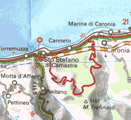
Topological Map of Canneto di Caronia Area
The next image allows one to examine the terrain in the Canneto area to see if anything like an old volcano crater is apparent.
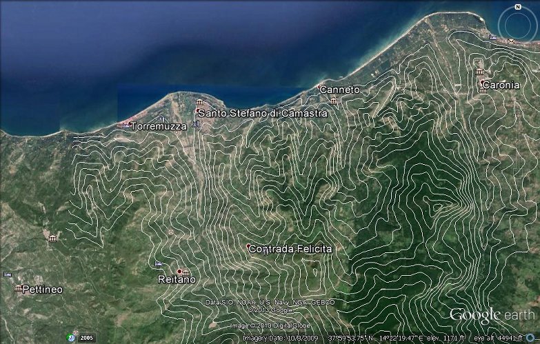
Google Earth image of Canneto di Caronia area showing 200 foot elevation contour lines
The contour lines do not show an obvious crater-like character but they look as though there may be evidence of lava flows. (Still checking.) [Added 11 Sep 2013.]
17 March 2004
The author, as stated earlier, is still of the opinion that the fires at Canneto may be precursors to an earthquake or some other kind of seismic activity.
Nicholas Hawkins says (This may have been done already, but the author has seen no news to that effect.) that air samples should be collected at Canneto and subjected to mass spectroscopy to see what unusual gases or suspended solid particles may be present. Electrical sparks or arcs (regardless of their source) without some form of flammable fuel-air mixture, can not trigger some of the fiery events that have taken place at Canneto.
If investigators rule out suspended volcanic dust and/or other flammable particulate matter, then a gas such as Methane, which is colorless, odorless, and lighter-than-air, would be a prime suspect. Methane, or some other related gas, seeping out of the earth (from a non-shallow source) might well be considered to be seismically related.
18 March 2004
VILLAGE BLAZES AGAIN - Canneto di Caronia is reported to have fires
breaking out again. Residents, returning after a one month evacuation, are
reported to be witnessing the same kinds of fiery events as they did two
months ago. "Disconnected fuse boxes have burst into flames, car central
locking systems blocked up and mobile phones have caught fire." Source:
Mirror.co.uk - Thursday 18 March 2004 06:11 p.m. [No longer latest news.]
Courtesy -
Google� News Alerts (BETA).
25 March 2004
According to the Istitutio Nazionale di Geofisica e Vulcanologia - Sezione di Palermo (INGV-Pa), soil gas emissions are common on our planet and originate from such sources as magma bodies, mantle degassing, metamorphism of limestone, rock breaking and in some cases organic activity. Soil gas emissions have been found in the central and south part of Italy. The emissions are either Carbon Dioxide or Methane dominant. In both cases they are associated with lower amounts of Helium, Radon, Nitrogen, Carbon Monoxide and Hydrogen.
The INGV-Pa article/report goes on to say: Volcanic and seismic areas are generally associated with anomalous soil gas emissions. The intensity of the emissions is not constant with time and also the spatial distribution can evolve, closely following the natural systems mentioned above. For this reason, flux variations, both in time and space, can give an important contribution into the study of volcanic and seismic phenomena.
Are soil gas emission studies being conducted at Canneto di Caronia? For the
complete INGV-Pa article see:
General information on Soil Gas Emissions(*) (In English)
(*) The URL http://216.239.37.104/translate_c?hl=en&u=http://www.pa.ingv.it/sd/sdgeneral.html for
the INGV-Pa article needs updating. [22 August 2005]
* See A Canneto di Caronia (ME)
(Italian),
(English).
[Added 25 Apr 2004.]
[Two-sentence paragraph removed - 14 Feb 2016.]
See An introduction to magma dynamics.
Anomalous Sicilian Coastal Uplifting
(Added 27-29 March 2004)Sicily's eastern coast near Mt. Etna shows evidence of what might be a bulging-type uplifting, similar to that depicted in the left-hand rising magma branch in the USGS poster just mentioned. (Alternately, the eastern side of Sicily may be sliding over a big bump. If so, the bump would currently seem to be under the Mt. Etna region.)
The evidence of bulging uplifting pertains to the current elevations of Sicily's last interglacial coastline(3), called MIS 5.5. (The abbreviation "MIS" stands for Marine Isotope Stages.) At Catania, which is about 28 kilometers south-southeast of Etna's peak, the MIS 5.5 coastline has been uplifted above current day sea level by 150 meters. (This is compared to 3-4 meters uplift for the same coastline at the more-or-less stable "stand still" westernmost region of Sicily.) The referenced article is not written for laymen but there is a very informative map that shows sites of measured Sicilian coastal uplifts, and related pictures. The map and pictures follow the references.
The following maps and graphs show uplift information for the north and east shorelines of Sicily. The red and green dots on the maps correspond to where MIS 5.5 shoreline uplift measurements have been made.
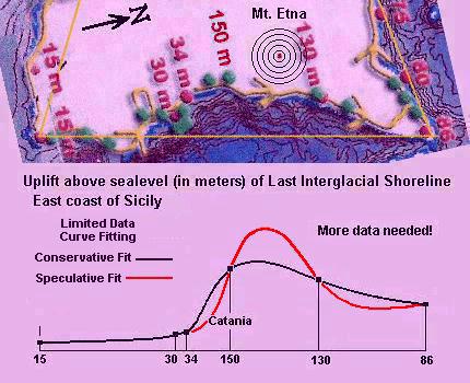
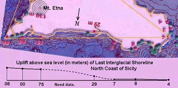
The Sicily map used in these graphics is from the article, Ref. (3), just mentioned.
9 April 2004
This is, in a sense, a rehash of the author's comments on 17 March 2004 but with a different twist.
In reviewing news reports about the fires at Canneto di Caronia the author notes two things that may be worth considering. (1) The fires are called spontaneous. (2) They seem to occur only in the presence of human activity. (One needs to be careful with the word only)
The word spontaneous evokes a picture of things happening without apparent triggers, which may or may not be the case. For fire to occur, as any well trained firefighter will tell you, you normally need three things: fuel, oxygen, and some kind of ignition mechanism.
Oxygen is pretty much a given.