A Communicator's Speculation
The Connected Earth Line of Sight Communications Introducing Communications webpage says, "Most primitive distance communications used visual devices that on a clear day could be seen up to 25 miles away."
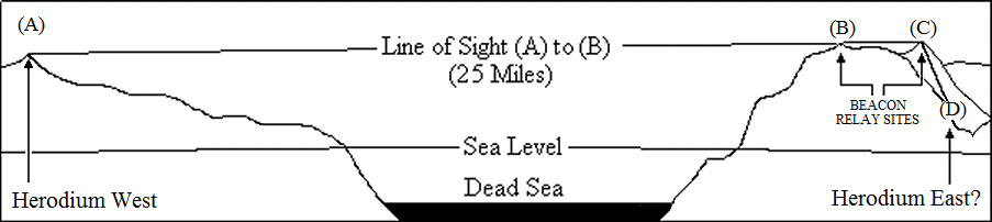
The following drawing shows a speculative visual signalling relay path connecting Herodium (A) near Bethlehem ("Herodium West" in the drawing) and the hypothetical Herodium adjacent to the spring ('Ain) at er Raya. There is a clear optical path between Herodium West (A) and Machaerus (not shown) but a highlands ridge at (B) prevents direct signalling between (A) and my proposed relay site at (C). If this (A) to (C) path is required then a relay beacon site would be needed at (B).
Hypothetical beacon relay system spanning the Dead Sea
An alternate route between Herodium West and the fortress at er Raya might consist of a 25 mile leg to the south from "Herodium West" to Masada, followed by a 24 mile relay leg (across the Dead Sea) between Masada and the Mountain peak relay site (C); and a one mile relay leg between the mountain peak (C) down to the fortress at er Raya (D).
Bald Face Speculation
[Added 15 October 2010.]
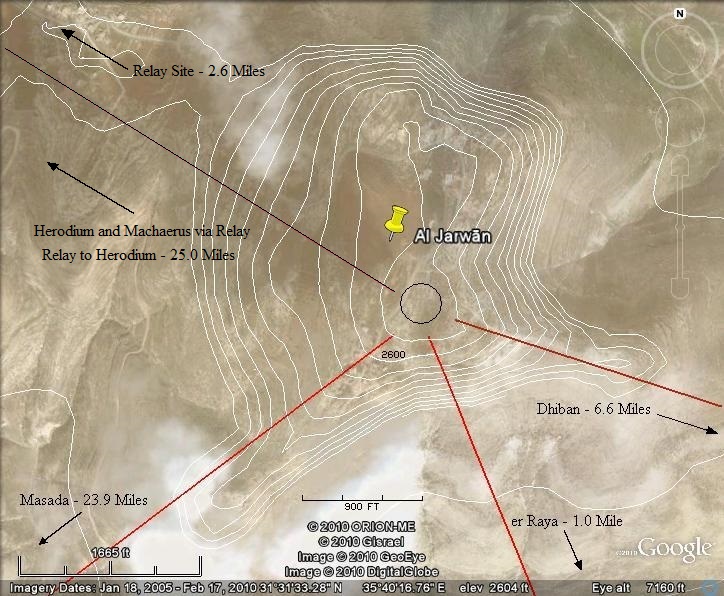
The following Google Earth image shows elevation contours around the mountain top and a black circle which represents the size of the cylindrical footprint of the Herodium southeast of Bethlehem. If there ever was a fortress at Jabal Al Jarwān, then it must have been disassembled and its building stones transported to other locations. There is a fairly level highlands road system to the Northwest of Al Jarwān which could have facilitated transportation of the stones.
Top of Jabal Al Jarwān showing the speculative footprint of a Herodian fortress
Jabal Al Jarwān is not an uplift mountain. An examination of the topology of the region shows that the flat topped "peak" is actually a small mesa-like structure surrounded by erosion canyons.
If Herod's observers had the use of telescopes (See: http://ancientskyscraper.com/224801.html "Ancient Technology in Telescopes" Link needs update.) the top of Jabal Al Jarwān would have been a much better location for observing Nabataean activity than er Raya. (The er Raya mound is some 1600 feet lower in elevation.) From a hundred foot tall tower, Herodian observers would have had a 430 foot height advantage with respect to the Nabataean population center of Dibon located some 6.6 miles ESE from Jabal Al Jarwān.