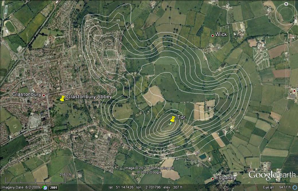
Area of Glastonbury Tor with 25 foot elevation contours.
Glass Sea Isles[An alternate title to this page might be "Bristol's Other Channel."]
Installed 20 Dec 2012. Latest update 10 Sep 2013.
In mid-December of 2012 I finished a re-write of an article about the Mithraeum at Caesarea Maritima in Israel. After sending the article off for peer review I decided to see what other written materials I had missed. I searched Google Scholar for Mithraeum Caesarea (with no quotation marks). Hit number 237 was a book by Justin E. Griffin, titled Glastonbury and the Grail: Did Joseph of Arimathea Bring the Sacred Relic to Britain? I couldn't tell, from the Google Books listing whether either or both of the search words were present in the book, so my wife kindly ordered it for me. On page 80 of Griffin's book there is a reference to a possible Mithraic Zodiac in the Old (Oldest?) Church at Glastonbury. Griffin may be stretching it, but he says, "It may well be that the simple Ealde Chirche was built on the foundation of a slightly earlier Roman building, perhaps including a tessellated mosaic floor."(1) Before encountering Griffin's book, I was not aware of Glastonbury, in southwest England, or that it is reputed to be associated with the legendary Isle of Avalon of King Arthur fame. When I want to know more about the geography of a place, especially when it involves a big hill, such as the Glastonbury Tor, I like to plot elevation contours on a Google Earth image of the area. In this case, this exercise has taken me out to sea, to the ancient Sea of Glass. I suspect that it's going to take me other places too. This webpage was originally put together to show elevation contours associated with the Glastonbury Tor on what was known as the Isle of Avalon. Early on, I came across accounts which indicated that the Isle of Avalon, along with a larger island to the north, the Isle of Wedmore, were formerly located in what was known as the Sea of Glass. The study has expanded to look at the larger picture. This first Google Earth image is of the Glastonbury Tor and shows elevation contours spaced every 25 feet from 450 feet down to 175 feet. It's contours do not reach all the way down to what I think was the orignal coast line of the island. |
|
According to the website
Glastonbury - Ancient Isle of Avalon, "In ancient times Glastonbury (Glass-town-borough) and the surrounding hills were islands in a swampy inland
sea called the Sea of Glass." [I suspect that the Sea of Glass harks to an earlier
time than the swampy inland sea.]
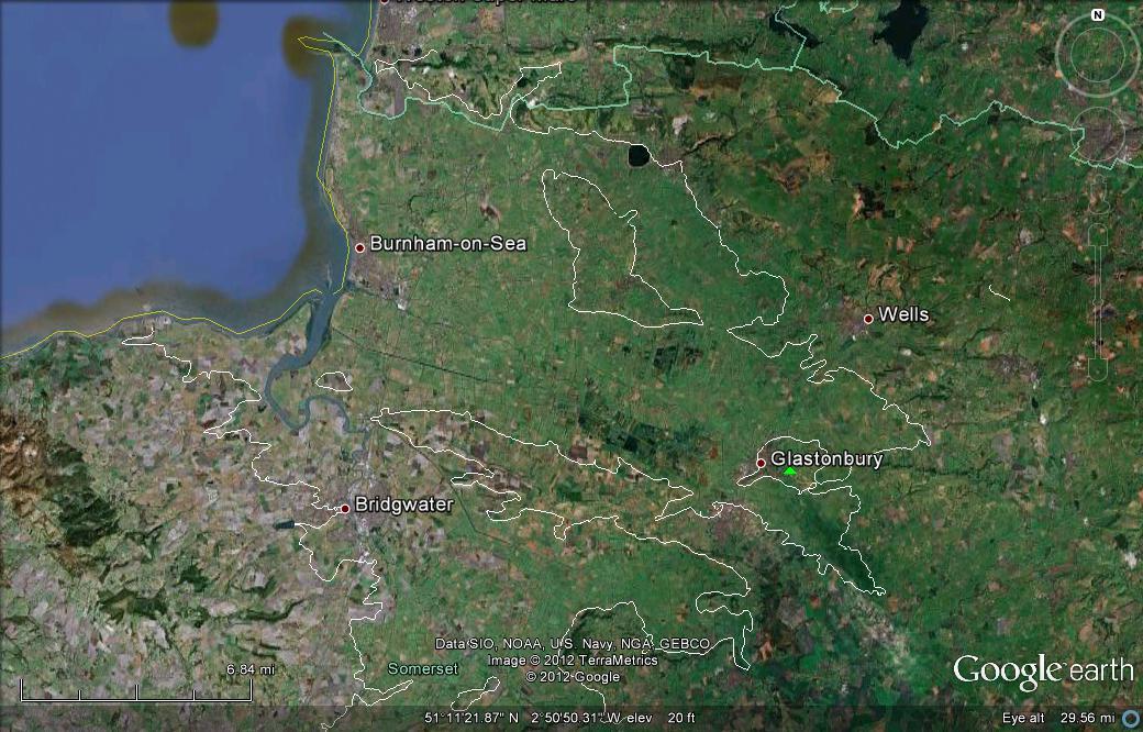
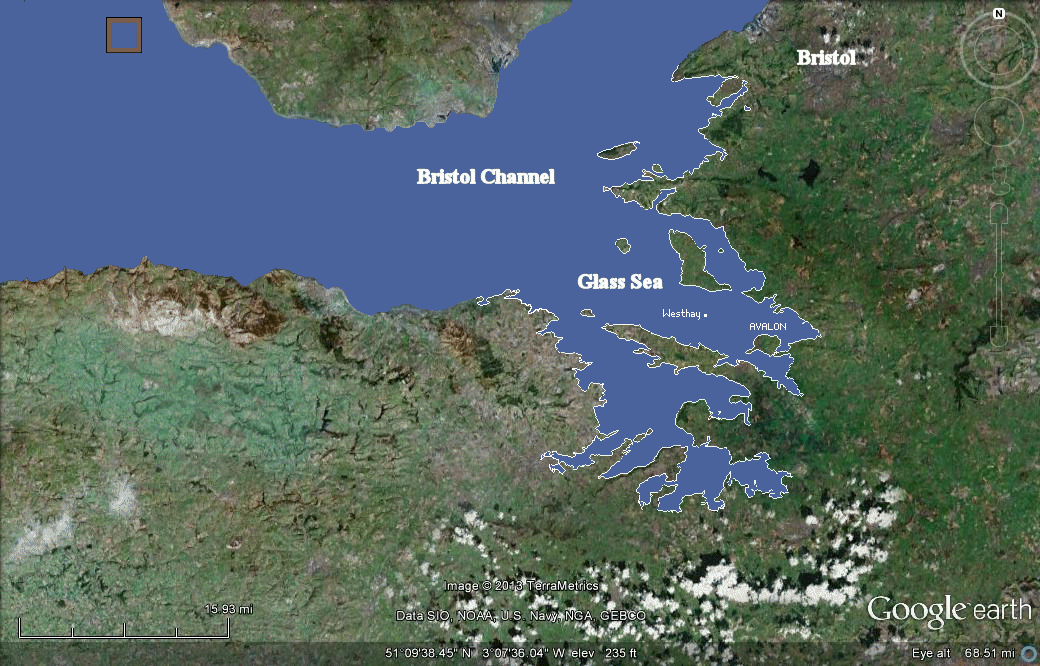
According to the webpage Glastonbury: The Isle of Avalon? the ancient British name [of Avalon] was Ynys Witrin, which may translate as "Island of Glass," though this is disputed. The author of that webpage says that "Island of St. Gwytherin" is a more plausible explanation. [I reserve judgement on this for now.] This second image shows where I think the coast lines were for the Sea of Glass. |
|
The coastlines of the ancient Glass Sea are approximated by 50 foot elevation contours. . The
elongated island-like feature east of Burnham-on-Sea is known as the
Isle of Wedmore. The Isle of Avalon, with Glastonbury on its
western shore, is some seven miles southeast of the
Isle of Wedmore. The green triangle marks the location of the Glastonbury Tor
|
|
In keeping with the idea that there was really a Sea of Glass, associated with a large-scale natural calamity, the following excerpt is transcribed from a paper about Atlantis type events.(2)
[In places the text reads awkwardly, most likely due to the vagaries of old literary sources.
'The Britons believed in the elusive Isle of Avalon, Avilion, or Ynys yr Afallon. Some have derived it from Avalloc, god of death; but from the apples of Eden and the Hesperides to those of the Edda legend and the Isles in the Irish Tales the apple has been symbolic, and the name is probably merely the "Apple Island." It was also the Isle of Glass, Isle de Voirre, and so confused with Glastonbury "urbs vitrae" one recalls the Currach of glass in the story of Connla, the bridge of glass in "Maelduin," and the great crystal tower (or iceberg) with fringe of crystal. The Welsh too had their giant land sunk by a drunken, careless prince. There was also the lost land of Lyoness, or Lennoys, of which the Scilly Isles are said to be the last remnants. Florece of Worcester (died 1118) tells of its flourishing condition and how it sank, like Atlantis, beneath the waves. It, like Avalon, was never placed on the early maps, and there is no evidence that it affected either the Irish or the Iberian beliefs, though it secured a place in English literature through Tennyson and Swinburne.' The following information about Somerset is kindly furnished by Dr. Myron Evans, a citizen of Wales. Somerset is just across the sea from here and in modern Welsh is "Gwlad yr Haf", land of summer, next to Dyfnaint or Devon, Land of the Deep Streams. It used to be Celtic speaking, probably Brythonic akin to Welsh (or Cymric, the main language of ancient Britain) rather than Brythonic akin to Cornish (a distinct language). The modern Welsh for Afalon is Afallon, (emphasis on the second syllable) and it is said that the first distinctly Christian church in Britain (Llan Duw or Landew) was started in Glastonbury in the year 37 A. D. by St. Joseph of Arimithea. It would have been founded on the six thousand year old druidical tradition mixed with Coptic and Hellenic. This Insular style of the age of the British and Irish Saints reached its intellectual peak under my remote ancestor Dewi Sant (St David) in the sixth century, . . . and profoundly influenced Ireland. Its greatest art is the Book of Kells. In modern Welsh "glass" is "gwydr", so the Celtic "gwydrun" or gwitrin is similar. Some of the Arthurian legends are based on Afallon, which is roughly equivalent to Valhalla in the Norse mythology. Afallon is the paradise of the dead, to which King Arthur was taken when mortally wounded. He is expected to return from there to inspire his People once more. Some inspiration is sorely needed to keep spoken Welsh alive. Afallon is very similar to the Irish concept of Tir na n Og, Land of the Eternally Young. This translates literally to Tir y Ieuanc in Welsh but Afallon is the same ancient Celtic concept, maybe six thousand years old. It is probably derived from a Indo European concept about thirty thousand years old. The real King Arthur is thought by some scholars to be Prince Owain Ddantgwyn Arth ab Einion Ddraig, fifth to sixth century Prince of Powys (the mid part of ancient Britain). He is was Owain (or Owen) the White Toothed Bear, son of Einion the Dragon. So the word "arth" was merged with the Latin "ursus" to produce Arthursus, or Arthur. "Ursus" is the Latin for "bear" as you know. The Indo European root is "Art" and "Urs". or "ar" or "ur". In Germanic the root "ar" is preceded by "be" as in "become", "beguile", "bewitch" and so on in modern English, so we get "be ar", or bear. "Afallon" frequently occurs in modern Welsh poetry as a metaphor for the land of the eternally young. The sea of glass or Mor y Gwydr is the well known low swampy area in Somerset. Glastonbury has an enormous Celtic ring fort (or "Dun") nearby. It is a gigantic construction indicating a high level of organization. Stonehenge is also druidical and an incredible feat of engineering and organziation.
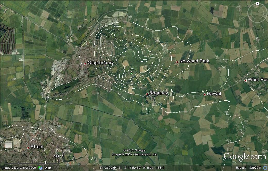
Here is a marked up Google earth image of the Bristol Channel area in which the land below the elevation of 50 feet is shown as water. (This figure is meant to be scary.) My speculation about the Glastonbury tor being a man-made tsunami refuge has been removed. A new speculation, offered here, is that the tor is the back end of an iron-rich asteroid which literally plowed into the earth from the northwest. [09 Aug 2013.]
|
|
In a 4 Jul 2013 email Jenkins says "... the Tor is not man-made. It is an anomalistic geological feature (there are several in the area). But it is superficially man-shaped - the banks on the Tor were fashioned during the Megalithic period (the stone circle building time). I'd suggest you forget the issue about the Tor being 'built as a tsunami refuge'. Tsunamis originating from a deep sea-cliff SW of Ireland do happen, but insufficiently often to justify major building works - the last time as 1608. But tsunami waves in 1608 reached only as far as Westhay - there was secondary flooding as far as Glastonbury, but it wasn't disastrous and affecting the land as much as it affected the coast. 20,000 people around the Bristol Channel coast were killed in the 1608 tsunami."
References(2) Thomas Johnson Westrop, 'Brasil and the Legendary Islands of the North Atlantic: Their History and Fable. A Contribution to the "Atlantis" Problem,' Proceedings of the Royal Irish Academy. Section C: Archaeology, Celtic Studies, History, Linguistics, Literature, Vol. 30, (1912/1913), p. 238. [This article was found through the online services of the academic archive JSTOR.]
(3) Palden Jenkins, The Ancient
Land Around Glastonbury.
On Finding an Ice Age Book -
Dr. Bernard E. Northrup - An abrupt awakening to the requirement by the catastrophic contents of the Book of Job to recognize a post-Noahic flood, thoroughly Biblical, ice "age" catastrophe.
|
Contact: Bob Fritzius at:
fritzius@bellsouth.net